For this I followed a trail of links, starting at London footprints, which offered a route around the are (url: http://www.london-footprints.co.uk/wknewcrossroute.htm). From here I was told that where today stands an Iceland supermarket a V2 bomb fell during WW2, killing 168 people, injuring another 121-"the worst incident of the entire V campaign" (see url: http://www.flyingbombsandrockets.com/V2_maintextb.html). This also explains why the age and style of the building in this part of the road varies greatly to most of the other, older buildings- as is the case with most European cities affected by the WW2. A search through the BBC's website leads us to the account of Barbara Smith (url: http://www.bbc.co.uk/ww2peopleswar/stories/63/a4901663.shtml) sharing her personal experience of the incident.
Searching for 'New Cross Road' on youtube brings with it largely personal type of footage, often not related to the area. However, there are two clips that I wish to draw attention to. The first depicts the fire of local school, and whilst this did not take place on the actual road it is a digital representation of an incident that directly affected the lives and futures of many living in the area and whilst in the past it would have been transmitted through other media or word of mouth (see Babara Smiths account above) it is now available to be relived in visual form. The second is taken from inside the Cafe Crema and depicts a side of New Cross Road more closely linked to another educational institution in the area. I have put the two next two each other as this sort of juxtaposition of conflicting yet related information is characteristic of research conducted via the Internet.
A third incident that has come up in my search of history of the local area (for example on the wikipedia page referenced in a previous post and also in a report on Deptford, produced by Dr. Gareth Potts and available at url: http://www.ucl.ac.uk/urbanbuzz/downloads/projects_09/Deptford_Case_Study.pdf) is the 1981 fire at 439 New Cross Road in which thirteen black youngsters were killed and which resulted in protests against what was seen as a racially motivated attack. The issue of race is also pertinent in the so-called 'Battle of Lewisham' in which anti-fascists clashed with National Front members and police forces on New Cross Road in 1977 (see url: http://www.irr.org.uk/2007/september/ha000019.html). As Dr Potts report on the area of Lewisham as a whole (and it is in this borough that New Cross Road is officially situated) the are still has a diverse ethnic make up, but I could find no reports of any other major instances of race related confrontations or tensions.
Thursday, 16 December 2010
Other maps: other sorts of sensory impressions: levels of noise

What we have here is a 'noisemap', compiled by and freely available from Defra, the 'Department for environmental, food and rural affairs' at URL: http://ww2.defra.gov.uk. All I had to do was search for the post code 'SE14' and it presented me with this map. From here I can deduce that the level of noise pollution on New Cross Road (essentially just the stretch of road running from West to East in the centre of the map, see below post on using google maps to compare) is at very high, unhealthy levels.
Offered on the same page we then have access to 'population exposure' which gives the following pie chart:

Whilst of course this sort of chart has its limitations it does strongly indicate that there is a minority of about 5% in the area bound by the above map that lives with a level of noise deemed as unhealthy by this particular government agency. Also from the streetview tour I conducted earlier it was clear that above all the shops there are residential homes (one could zoom in and inspect courtains and sometimes even see into people's living rooms). These most likely make up the bulk of the 5% who suffer noise of 70 dB and over.
Impressions from google maps, street-view, satellite.

On the google maps home page one is greeted with a the United Kingdom, the Republic of Ireland, little bits of France and Norway as well as a lot of blue frame the state. Twice I click on London and the map zooms closer. I repeat this four time, now I have arrived at a map that shows London as a spider's nest, inside what looks at first like a circular river but is in fact a the notorious circular motorway of the M25. Eventually I can see the are of New Cross Road, as bound by the two New Cross train stations.
The map has local businesses advertised, mainly pubs and restaurants. For some of these reviews appear as you hover over them, for example the New Cross Cafe Diner is said to offer 'Good choice of breakfast... if you get your timing right it's full of sexy builders' whilst The Goldsmiths Tavern is said to have 'electric nights'. Clearly this is a limited exploration of the area but at least it does hint at people partaking in social life in the area.
Next I select and drag the little yellow man in the top left corner of the map and drag him to New Cross Gate station.
 On the left we see the image that we are now presented with and this immediately makes shows the place as being a busy place, both for people as well as for traffic. I follow street view along my selected path, each click briefly distorting what I see only for it to show me a new stretch of the north side of the road, complete with people, shops, and traffic. As I keep clicking my way along, at times making use of the various viewing tools that allow me to zoom in and change my angle of perspective I am reminded of the the sci-fi film Blade Runner in which a detective played by Harrison Ford makes use of a similar set of tools. Soon I find myself with a task of my own; to figure out on what day these images were taken. Through zooming in on newsagents shops I eventually find a board which shows the day's Evening Standard headline 'John Leslie Rape Quiz' and a quick google search tells me this is from the 24th of June 2008.
Depending on how I use the tool to scroll through the pictures I can either simulate the idea of me sitting in the backseat of a car that is driving along with the pace of traffic as I am interestedly looking out of the window and thus recreate the journey undertaken by the google car on this day, or by selecting to face not the sidewalk but rather the way of traffic I can get the sensation of myself 'free-running' over cars and buses in a hurried manner.
My impressions of the area are now further shaped by this tool and no doubt for many people this is their first, or perhaps only, experience of this particular part of south east London. Thus great power rests within these images and the way they depict an area and it is in the interests of all who have a particular interest in these places to be aware of how they are depicted.
For the final part of this exercise I click on 'satellite'. Below I have copied and pasted the image that I was then presented with:
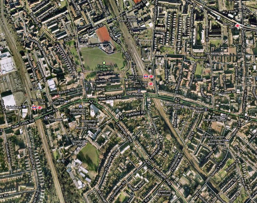 What is immediately of interest here is that if we compare the satellite view to the first map at the top of this post we now see all the empty spaces not occupied by roads filled with houses, trees, large green spaces, and railway lines. So whilst this view serves less well for navigation it does let one know that this is in fact a road that has large park areas as well as streets with impressively sized houses in close proximity. Where this tool was less useful than streetview was when one utilised the zoom function as the image quality was much to low for anything of interest to become visible.
Monday, 13 December 2010
First port of call: A simple google search.
I would like to commence this project as most people who are seeking information on the Internet begin: by using google. Here are the top 5 results for the search term 'New Cross Road', from a London IP address of course:
1-http://www.londontown.com/LondonStreets/new_cross_road_6ee.html
2-http://en.wikipedia.org/wiki/New_Cross
3-http://en.wikipedia.org/wiki/New_Cross_Gate_railway_station
4-http://www.londononline.co.uk/area/New_Cross_Road_SE14/
5-http://www.grace.org.uk/churches/nxbc/index.html
The londontown.com result is of interest only for how poor and unrelated to the actual street the information is. Here are linked information for businesses, some of which are local, others up to 40 minutes walk away. The two wikipedia articles are indicative of both the preeminence of wikipedia in online searches in general but also both are signs of what I presume to be locals taking an active interest in the online presentation and archivization of their communities. The londononline.co.uk link is of a type quality to the first, but at least all of the businesses linked to here were at least at some point to be found on New Cross Road. The final result is an indication of the relatively large church going part of the population that is to be found in the area.
Approximation towards a mission statement of intended purpose
This is an attempt towards creating a phenomenologically orientated ethnography using only resources that can be accessed from the digital sphere.
(Keeping in mind here the following: "[Christopher Tilley] argued that simply by looking at two-dimensional depictions of a landscape, such as on a map, archaeologists fail to understand how peoples living in hunter-gatherer and agricultural societies actually related to those areas - he believed therefore that investigators should enter the very landscape which they are studying, and use their senses of sight, smell and hearing to learn more about how historical peoples would have interpreted it." (http://en.wikipedia.org/wiki/Phenomenology_%28archaeology%29) I believe that an archaeology in future may well have to rely on digital data but this need not have to mean that a phenomenological approach has to be discarded. A representation of sensory experience of an area can be achieved through the resources available from an online environment.)
I will here upload links towards a variety of resources that relate to the actual lived experience on the short stretch on New Cross Road as informed by the maps, blogs, articles, and any other sources that appear online. The culimnative of the impressions left by these sources will be written up to represent an attempt towards an ethnography carried out in the digital realm, utilising digital technology but focusing on an actual landscape which provides many people with the backdrop to a significant portion of their lives.
Just as the methodology will be primarily experimental so the method of presentation, primarily the writing style, will be experimental. This is as much an excercise to find out about the sort of impressions the tools available create, how they can be used, and what their shortcomings are as it is an actual attempt for me to find a method of ethnographic writting that suits my purpose. I will try and follow a variety of the voices that I have encountered during my time engaged with anthropology and will take first and foremost that there is no one correct way of conducting ethnography.
Tom Boellstorff attempted to create an ethnography that drew entirely on data collected by his informants in (Coming of Age in) Second Life (Princeton University Press, 2008) and thus never left the sphere of the virtual, arguing in stead that since humans have always conducted themselves through the virtual, be it language or myth for examle, his approach was valid for examing human experience.
In his Cocaine Museum (Pluto Press, 2004) Michael Taussig created a make belief museum to serve as "a vantage point from which to assess the lives of Afro-Colombian gold miners drawn into the dangerous world of cocaine production" (see URL: http://www.press.uchicago.edu/presssite/metadata.epl?mode=synopsis&bookkey=3614045). This here ought to serve as a collection of my own from which I hope to further understand this particular urban space.
Subscribe to:
Posts (Atom)